Mapping & GIS Solutions for Natural and Natural resources Daphna Shelef
With over a decade of experience in project management, spatial analysis, and GIS solutions, I support decision-makers, researchers, environmental planners, ecologists, agronomists, farmers, and others.
Among My Clients and Partners
Services & Solutions
Field Surveys for Mapping
GIS Support and guidance for Field Surveys, trees Surveys, vegetation surveys, and more. Providing assistance in defining survey needs, planning fieldwork, selecting appropriate sampling methods, implementing data collection solutions, and analyzing final survey data.
arcGIS online
Management, Development, and organization of geographic databases. Offering online data management solutions through the ArcGIS Online (AGOL) platform or other tools, tailored to client needs.
Spatial Analysis & Geostatistics
Conducting Advanced Spatial analisys and developing geostatistical models to support Data-Driven Spatial Decision-Making.
Mapping & Digitization
Creating GIS Layers and Maps from Any Spatial Data.
Support & Training
Providing guidance, mentoring, and instruction for mapping projects of all scales. Customized lessons, workshops, and lectures available upon request.
Remote Sensing
Leveraging satellite imagery for terrain interpretation, tracking vegetation growth in agricultural plots or open landscapes, assessing wildfire-affected areas, evaluating damage in farmland, and more.
Tailored made Solutions
Consulting & Custom Solutions for optimal mapping and spatial Data Management. Providing expert guidance in selecting the best solutions for various mapping needs, geographic database management, map production, and more.
Project Management
Comprehensive project management from inception to Execution. Managing projects from the initial planning stage, including needs assessment, field data collection, GIS support and management at all scales, and delivering progress reports and documentation.
Where Space and Technology Come Together Let’s Find the Best Solution for You
Where the need for nature conservation meets technological advancement, and where research and fieldwork converge with data, lies the key to making informed, effective, and impactful decisions. This is where geography, GIS, and I come together to create meaningful insights.
Daphna Shelef

A deep love for nature and a strong connection to landscapes, plants, and wildlife inspired me to pursue a career in ecology and natural resource management.
For my master’s research in forest ecology at The Hebrew University of Jerusalem, I conducted fieldwork at Ramat Hanadiv Nature Park. Following that, my work at the The Society for the Protection of Nature in Israel (SPNI) and various startups specializing in precision agriculture allowed me to develop expertise in mapping open spaces, natural resources, agriculture, and forests – both in Israel and globally.
As a trained ecologist, I have spent extensive time in the field, witnessing firsthand the vital role of data collection and spatial mapping in environmental research and decision-making. My expertise lies in bridging advanced mapping technologies with practical field applications, delivering data-driven solutions that address real-world challenges.
Since 2014, I have been providing consulting services and customized GIS solutions, covering everything from field data collection and map production to spatial analysis, GIS portal management, user support, and tailored solutions for complex projects.

I work with a diverse range of clients, each with unique needs – including environmental planning firms, landscape architects, agronomic consultants, farmers, and institutional organizations such as JNF and the Agricultural Research Organization. How can GIS support your work?
Click here to send a WhatsApp message or fill out the contact form.
Project Examples
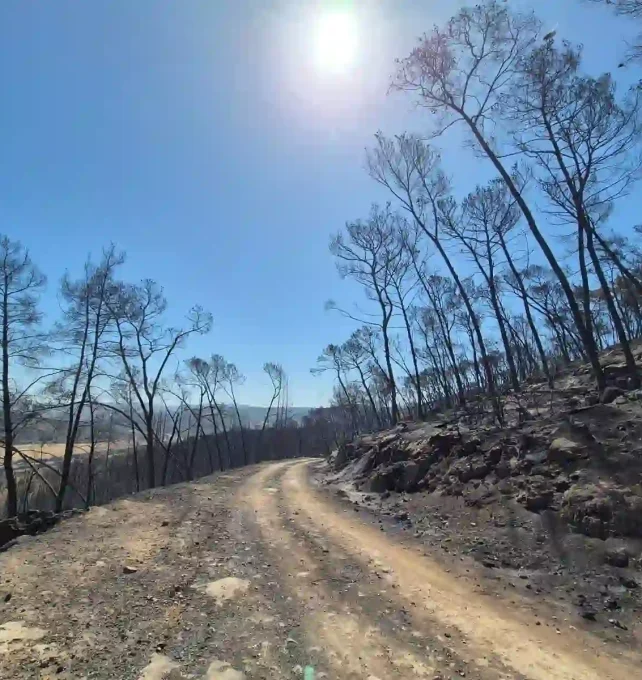

Mapping Fire Damage in Eshtaol Forest Using Remote Sensing
Following the major wildfire that broke out in April 2025 in the Eshtaol Forest, I conducted a remote sensing-based damage assessment using Sentinel-2 satellite imagery. The resulting map (see article in Hebrew) analyzes fire severity across the affected area, distinguishing between zones with varying levels of impact. This up-to-date, high-resolution analysis serves as a key decision-support tool for post-fire recovery planning and coordination between the relevant stakeholders managing the landscape.
Rapid & Tailored Solution
Remote Sensing
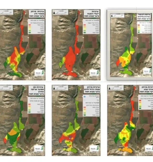

Development of a Prioritization Model for Managing Invasive Species in Forests
This project involves the development of a practical model based on eight key parameters to prioritize management efforts for invasive species in forested areas. The work supports the research process from start to finish — beginning with field data collection, including needs assessment, design of a dedicated field application, integration of drone-based data, and data refinement — through to the creation of an advanced analytical model. The model evaluates the influence of each parameter on the invasive species’ ability to establish itself, and integrates them into a single weighted index that determines the priority level for treatment across the forest landscape.
Project Management
Spatial Analysis
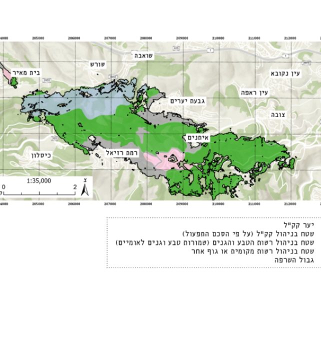

Fire Damage Assessment by Land Classification – August 2021
Between August 15–18, 2021, approximately 11,000 dunams of forest were burned in the Judean Hills.
The majority of the affected areas were in the Jerusalem Hills Memorial Forests and Staf Forest, managed by KKL-JNF, while a smaller portion was in nature reserves under the jurisdiction of the Israel Nature and Parks Authority (INPA). A minor part of the burned area extended into agricultural lands belonging to nearby moshav communities (Asam & Chover, Ecology & Environment, February 2022 – click here for the full article).
The map illustrates the burned area, categorized by the responsible land management authorities.
Creating this map requires in-depth familiarity with multiple GIS data layers and an understanding of how different agencies operate on the ground – for example, INPA-designated land managed by KKL-JNF.
Remote Sensing
Spatial Analysis
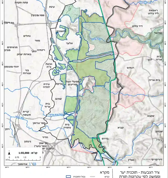

Comprehensive Mapping for Forest Management Plans for KKL
As part of the development of long-term forest management plans for KKL, I carried out comprehensive mapping and analysis to support informed planning decisions as part of the planning team. The work included collecting and reviewing existing data to understand the current condition of the forests, producing a detailed “current state” map book, conducting field surveys, defining thematic planning needs, and delineating long-term management units. The final output includes three thematic maps addressing key management aspects: fire protection, visitor access, and ecological values.
Mapping of Management Units
Field Surveys
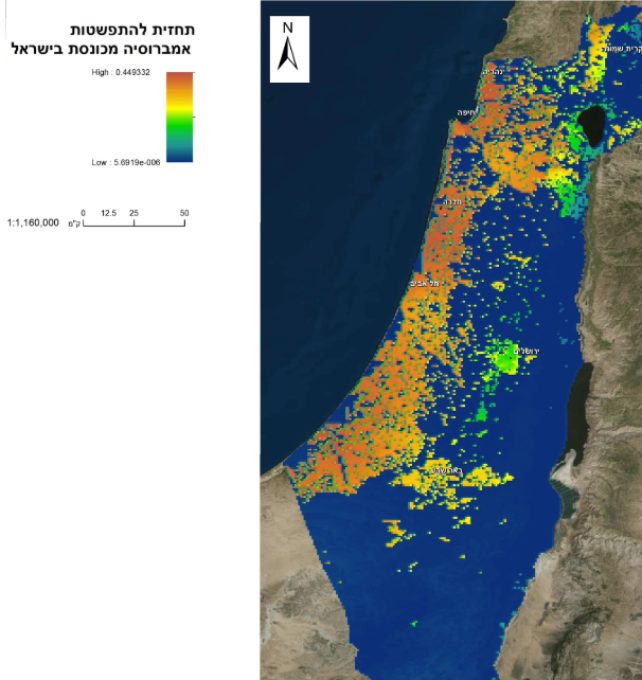

Ambrosia Spread Prediction Model in Israel
Implementing New Spatial Approaches for Managing Invasive Species in KKL-JNF Forests.
The prediction is based on the MaxEnt ecological model, a tool for modeling species distribution. Using field observations and spatial ecological models, this study forecasts the potential spread of Ambrosia confertiflora, an invasive plant species in Israel. The findings contribute to research on Ambrosia expansion in Israel and offer a comparative analysis with its spread in the United States and Australia.
Spatial Model
Reseqrch


Programmatic Mapping for the Judean Hills Fire Recovery Project, Managed in AGOL
Generating a Polygon Layer for Restoration Based on a Schematic Paper Map Created by Land Managers.
The restoration plan, outlined by the KKL-JNF team, was digitized and integrated with existing layers, including firebreaks and land use designations. Each restoration polygon was enriched with attribute data, making it an integral part of the GIS layer.
The finalized layer was uploaded to the client’s AGOL account and shared with relevant stakeholders involved in the project.


